|
We are proud to present AirTrack NG, the remake of the classic app that integrates with flight simulators in order
to report flight and navigation data in real time on a number of devices.


Designed to integrate with a flight simulator such as X-Plane or Microsoft Flight Simulator
2020, with the aid of a plugin this application allows you to
track and control your flights in real-time in the palm of your hand.
You no longer need to stay glued to the computer in order to know if you're
still flying at 39,000 feet, if you're still heading to the right waypoint,
how long you've got left or what the weather is going to be like at your
destination airport; you can now relax and do it in the garden while you read
the newspaper.
Run multiple panels in multiple windows and across multiple monitors on the
Mac, with dual panels on iPad or on single panels on the iPhone, scale and
rescale, or run across multiple devices all connected to the same flight.
With its updateable AIRAC navigation data, AirTrack includes all the data
required for air navigation, namely intersections, VORs, NDBs, airports,
runways, procedures, airways, frequencies and localizers.
The remote control features allow you to use your device as
a joystick to control the simulator, to control its auto-piloit with the MCP,
to send flight plans and to tune the radio stack.
But if this isn't enough, AirTrack can also use your device's built-in GPS to
determine your current movements and the Internet to download real weather
to simulate an aircraft's sensors.
AirTrack's current list of features includes:
A replica of the 737 NG Primary Flight Display (PFD) with:
Speed
Altitude
Vertical Speed
Altimeter/QNH with EFIS control
Outside Temperature
Compass
Attitude Indicator with roll and pitch
Flight director
Flight Mode annunciators
Instant GS, IAS, MACH, and VS when available
Movement sensing remote control of the aircraft
Attitude sensors on selected devices
Embedded EFIS panel for CPT, FO and standalone
Minimums / decision height control
ILS Approach mode with VOR/LOC and GS diamonds
| |
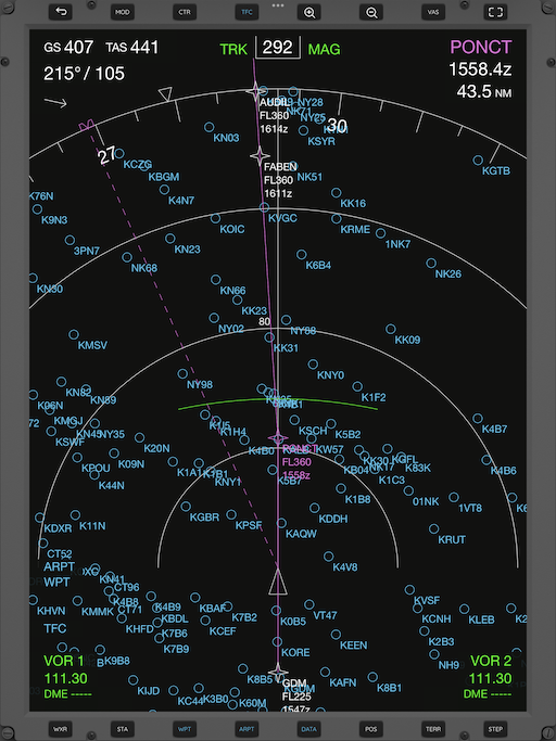
A replica of the 737 NG Navigation Display (ND) with:
Captain, First Officer and Standlone EFIS
APP, VOR, MAP and PLN modes
Centered and expanded modes
Display of WXR, STA, WPT, ARPT, DATA, POS, TERR and TFC
World wide maps under the TERR option
Fully independent TCAS display
SIMULATOR, VATSIM, IVAO and ADS-B traffic
Wind speed and direction indicators
True Air Speed and Ground Speed
Active waypoint reporting
Flight plan display
ILS / VOR approach course helpers
Runway and localizer orientation drawing
VOR/ADF selectors
VOR/NDB guidance bugs according to NAV/ADF
Plane trail
Rate of Turn display with the snake and 30, 60 and 90 secs predictions
ILS Approach mode HSI with deviation bugs
A 737 NG based Mode Control Panel (MCP) that interacts with the simulator's auto-pilot with:
COURSE1, COURSE2, HEADING, IAS/MACH, ALT and VS dials
FD, CMDA, CMDB, CWSA, CWSB, DISENGAGE buttons
N1, VNAV, SPEED, LVL-CHG buttons
HDG SEL, LNAV, VOR/LOC, APP buttons
ALT, VS buttons
C/O, SPD/INTV and ALT/INTV buttons
A radio stack panel with:
NAV1, NAV2, COM1, COM2, ADF1, ADF2 radios
Transponder setting and mode selector
Integrated Navigation Data with:
SAVED, SEARCHED and NEARBY points
Detailed Airport information including current weather
FIX, VOR/DME/TACAN NDB details
Custom waypoints
Air Account cloud based point syncing
Navigraph and FAA CIFP updateable AIRAC cycles
An advanced flight planner with:
Departure and arrival airport and runway selection
SID, STAR and Approach selectors
Direct route entry
En-route airways
World routes suggestion engine
Cruising altitude with vertical profile calculations
Direct-To function
Load and Save with cloud service using an Air Account
Flight plan view with details of airports
Current METAR weather, transition altitudes / levels
Overall distance, RTE, ETA, ETE, and RTE calculations
Point-by-point flight plan detailed
Per point heading, distance, ETA, ETE, RTE reporting
EFB Charts and Documents with:
Local storage / browsing and display of PDF charts
Air Account Charts integration / syncing
FAA charts of the US
Plus the following generals:
Real-Time weather information for airports
Real-traffic sourced from ADS-B
Retina and super retina crystal sharp graphics
Resizeable panels; run in full screen or side by side
Multiple app and multiple simulators support
Options of buy once or subscribe for built in products
Next topic: Downloads
|